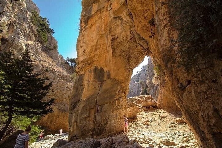
Diktamos Gorge
The canyon of Diktamos is located at the White Mountains. It starts 21km east of Chania, next to the village Katochori at an altitude of 300m, and ends 8km to the east, at the village Faragi, at an altitude of 40m and near the village Stylos, province Apokoronas. Therefore, this is also known as Katechori Gorge or Stylos Gorge.

The canyon stream is the main tributary of Kiliaris River, collecting water from the north slopes of Mavri peak and emptying on Kalives beach.
Hiking in the canyon is not very easy, with some places needing more attention, and lasts about 3 hours. The canyon is beautiful and lush with huge trees and has many steep slopes where the endemic herb of Crete, dittany or diktamos, grows. In Stylos you can visit the old church of Apostle John (Agios Ioannis Theologos), cool off from the local springs and regain your power in the taverns of the village.
Πηγή: ⭐ Travel Guide for Island Crete ⛵, Greece❗ - Diktamos Gorge cretanbeaches.com
https://www.cretanbeaches.com/en/gorges-and-canyons-in-crete/west-crete-gorges-chania/diktamos-gorge
Imbros Gorge
Start your walk at the village of Imbros in the region of Chania in western Crete. The location is 57 km south-east of the town of Chania. If driving, park on the south side of the village and begin your walk, you will see a wooden sign post.
Pay a small entrance fee to enter the gorge. The entrance is called 'porafarago' in local dialect and was heavily fought over when defending Sfakia from the Turkish troops. The track leads to the village of Komitades which is an 8 km hike. The path is quite rocky and all downhill. Take good walking shoes and your own water.
There is plenty of shade along the way from the trees and the sides of the canyon. Keep your eye out for raptors high above you and in the rocky cliffs. You will see many, many caves in the cliffs and rocky canyon.
This track is accessible all year, it is actually not closed, because it is not a national park, but care should still be taken in autumn, winter and spring months as rains will mean water... and water wants to flow down the gorge. Do not hike if there has been recent rain.
In the middle of the gorge, the 'mesofarago' is a historic Venetian water cistern.
Samaria gorge
The Samariá Gorge (Greek: Φαράγγι Σαμαριάς or just Φάραγγας) is a National Park of Greece since 1962 on the island of Crete – a major tourist attraction of the island – and a World's Biosphere Reserve.

The gorge is in southwest Crete in the regional unit of Chania. It was created by a small river running between the White Mountains (Lefká Óri) and Mt. Volakias. There are a number of other gorges in the White Mountains. While some say that the gorge is 18 km long, this distance refers to the distance between the settlement of Omalos on the northern side of the plateau and the village of Agia Roumeli. In fact, the gorge is 16 km long, starting at an altitude of 1,250 m at the northern entrance, and ending at the shores of the Libyan Sea in Agia Roumeli. The walk through Samaria National Park is 13 km long, but one has to walk another two kilometers to Agia Roumeli from the park exit, making the hike 15 km long. The most famous part of the gorge is the stretch known as the Gates (or, albeit incorrectly, as "Iron Gates"), where the sides of the gorge close in to a width of only four meters and soar up to a height of almost 300 meters (980 feet). The gorge became a national park in 1962, particularly as a refuge for the rare kri-kri (Cretan goat), which is largely restricted to the park and an island just off the shore of Agia Marina. There are several other endemic species in the gorge and surrounding area, as well as many other species of flowers and birds.
The village of Samariá lies just inside the gorge. It was finally abandoned by the last remaining inhabitants in 1962 to make way for the park. The village and the gorge take their names from the village's ancient church, Óssia María.
Visitors to Crete can complete the walk down the gorge from the Omalos plateau to Agia Roumeli on the Libyan Sea, at which point tourists sail to the nearby village of Sougia or Hora Sfakion, where they could spend a night there, or they could catch a coach back to Chania. The walk takes five to seven hours and can be strenuous, especially at the peak of summer.
Local tourist operators provide organized tours to the Gorge. These include bus transportation from one's hotel to the entrance (near Omalos village), and a bus connection that will be waiting for hikers after they disembark the ferry in Sougia or Sfakia (Chora Sfakion). If you are on your own, you can make a one-day round trip from Chania (see below) or from Sougia or Paleochora. Note that the morning buses from Sougia and Paleochora do not operate on Sunday. The ferries leave Agia Roumeli to Chora Sfakion (eastbound) and to Sougia/Paleochora (westbound) at 17:30.
There also exists a way from Agia Roumeli to the Gates and back.